‘Vigil’ by acclaimed author George Saunders kicks off the new Campus Reading Program
May 13, 2026
A team of researchers has created a computer model that accurately predicted the spread of COVID-19 in 10 major cities this spring by analyzing three factors that drive infection risk: where people go in the course of a day, how long they linger and how many other people are visiting the same place at the same time.
Northwestern University researchers partnered on the model with Stanford University researchers, including Jure Leskovec, an associate professor of computer science at Stanford Engineering, and David Grusky, the Edward Ames Edmonds Professor in the School of Humanities and Sciences.
Beth Redbird, assistant professor of sociology and a faculty fellow with Northwestern’s Institute for Policy research, specializes in human movement and interaction, often working with GPS data to understand how people move through space and come in contact.
“This study demonstrates that the way low-income neighborhoods are constructed, with smaller establishments that serve more customers, is one of the drivers of racial and economic inequality in infections,” Redbird said. “It also shows that, by reducing density in these locations, we might reduce this disparity.”
Jaline L. Gerardin, assistant professor of preventative medicine (epidemiology) at Northwestern’s Feinberg School of Medicine and McCormick School of Engineering, advised the team on the epidemiology and epi modeling.
“The really cool part of this work is that it isolates the role of mobility in affecting the trajectory of the SARS-CoV-2 epidemic,” Gerardin said. “By starting with a very simple epi model, imposing the actual pattern of human mobility on it, and pressing “play,” we were able to see that neighborhoods with lower income and a higher percentage of non-white residents end up with more infections, which is what happened in real life. What this means is that the higher risk of exposure in these populations during the first wave can be explained by mobility patterns without resorting to explanations like genetic susceptibility.”
The study, published today in the journal Nature, merges demographic data, epidemiological estimates and anonymous cellphone location information, and appears to confirm that most COVID-19 transmissions occur at “superspreader” sites — such as full-service restaurants, fitness centers and cafes — places where people remain in close quarters for extended periods. The researchers say their model’s specificity could serve as a tool for officials to help minimize the spread of COVID-19 as they reopen businesses by revealing the tradeoffs between new infections and lost sales if establishments open, for example, at 20 percent or 50 percent of capacity.
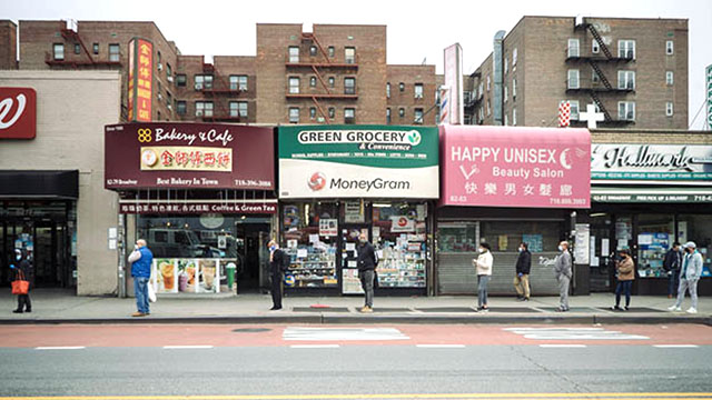
By combining their model with demographic data available from a database of 57,000 census block groups — 600 to 3,000-person neighborhoods — the researchers show how minority and low-income people leave home more often because their jobs require it, and shop at smaller, more crowded establishments than people with higher incomes, who can work from home, use home-delivery to avoid shopping and patronize roomier businesses when they do go out.
For instance, the study revealed that it’s roughly twice as risky for non-white populations to buy groceries compared to whites.
The team has made its tools and data publicly available on the COVID-19 Mobility Network Modeling site so other researchers can replicate and build on the findings.
“In principle, anyone can use this model to understand the consequences of different stay-at-home and business closure policy decisions,” Leskovec said.
This research was supported by the National Science Foundation, the Stanford Data Science Initiative, the Wu Tsai Neurosciences Institute and the Chan Zuckerberg Biohub.